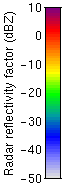
 Meteorological radars measure 'radar reflectivity factor'. This factor is essentially proportional to the size of the particles in the atmosphere, raised to the power six. The scale used in all the images is shown on the left. Larger particles, such as raindrops and ice crystals, have a higher radar reflectivity factor, so their radar echo is stronger. These particles appear as brighter areas of colour on the radar images. Smaller particles, which include cloud droplets and dust, have a lower reflectivity and so return a weaker signal to the radar. Small particles therefore show up as darker-coloured areas on the radar scans.
The radar images shown live on these pages were taken using a 35 GHz and a 94 GHz radar fixed near the main 25 metre antenna at Chilbolton. We are supplementing these images with real-time images from a lidar based at the same site. Lidars use light instead of microwaves to detect much smaller particles. Combining these two instruments will help us to identify the types of clouds and their compositions more easily.
Intepreting the images