A Halo Photonic Streamline Pro lidar operates continuously at Chilbolton Observatory. It transmits at a wavelength of 1.55 um. For most of the time it points vertically. Every 10 minutes it perfoms a conical scan 15 degrees off vertical at 24 azimuth equally spaced azimuth angles. It produces measurements of the elastic backscattering coefficient of aerosols within the atmosphere and the velocity of scattering particles along the beam direction.Velocity is measured
using the detected scattered radiation which has been Doppler-shifted as
a result of the movement of the scattering particles. When the instrument is vertical any velocity component from the horizontal wind speed is excluded. The scattering particles include cloud water droplets or ice crystals, hydrometeors such as rain or snow and any other particulate material such as dust or soot.
A heterodyne detection system, in which the measured signal is mixed with a sample of the original transmitted radiation, is used to measure the velocity of the particles. Finally, the instrument makes polarisation-sensitive measurements which provide information on the degree of symmetry of the scattering particles.
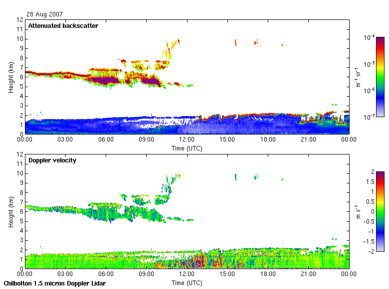
Example of measurements from 28 August 2007.
The upper plot shows the elastic backscattering coefficient. The colour scale indicates the strength of scattering. The higher levels, greater than around 10-5 m-1sr-1, indicate clouds. From 0 UT to approximately 12 UT ice clouds can be seen over the height range of 5 – 10 km. From approximately 13 UT lower cumulus cloud appears in the height range 1 – 2 km. As is normal with lidar systems it is not generally possible to detect higher cloud signals through lower cloud as the lidar beam is rapidly attenuated by the cloud. The lower levels of the atmosphere, up to around 2 km on this day, show backscattering signals of around 5 x 10⁻⁶ m-1sr-1. This indicates the boundary layer on this day. The boundary layer is the region above the ground in which the atmosphere is well-mixed and hence contains higher levels of aerosols originating primarily from the earth’s surface.
The lower plot shows the Doppler velocity measured along the vertical line of sight of the laser. Positive velocities are upwards, negative velocities are downwards. Velocity can only be measured where there is a measurable backscattering signal (upper plot). In the ice clouds either near-zero or negative velocities are measured. Negative velocities indicate falling particles. In the boundary layer both positive and negative velocities are seen, with the greatest values between 9 UT and 15 UT. These result from convection within the layer. Convection occurs most strongly when solar heating is at its greatest, normally in the middle of the day and during summer.