After the eruption from the main crater of Iceland's Eyjafjallajokull volcano commenced on 14th April 2010, the suite of lidars and the AERONET sunphotometer at Chilbolton Observatory were used to monitor volcanic ash layers over the site. Lidars wereused to measure the height of ash layers and their evolution with time. They also provide information which distinguishes ash from water clouds. The sunphotometer measures the aerosol optical depth and, provided the sky is completely clear, the size distribution of particles in the atmosphere. All the Chilbolton lidar instruments were used to observe the ash layers. The results shown here were recorded with the Leosphere EZlidar, as the depolarisation measurements are useful for identifying ash layers.
Volcanic ash was first detected at Chilbolton Observatory on 16th April 2010.
An ash layer is seen to descend from a height of 2.5 km at 12:30UT to 1 km at 15:30UT. At this stage the ash then becomes mixed with the more turbulent boundary layer, shown by the increased co-polar elastic scattering in the lowest 1 km of the atmosphere. The presence of the ash in the boundary layer is indicated by the increased depolaration ratio for several more hours. The depolarisation ratio is low for spherical particles such as water droplets and higher for more irregularly shaped particles such as volcanic ash.
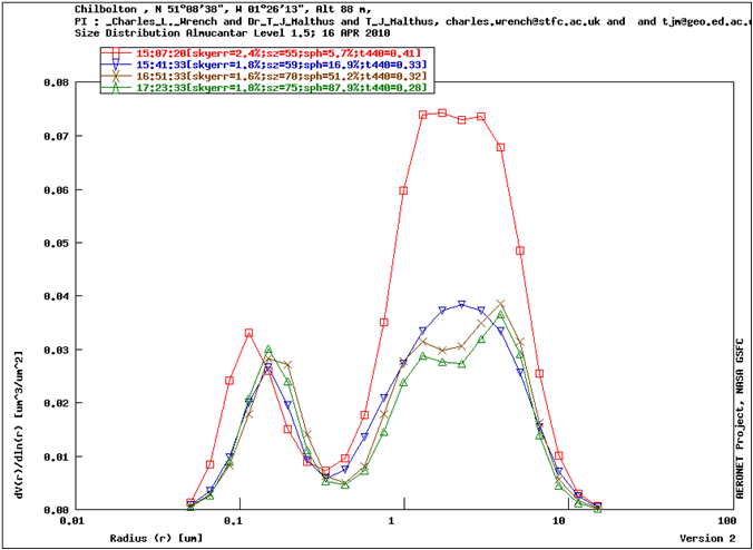
Measurements from the co-located sunphotometer show an increase in the concentration of particles of 1-2 microns in size as the layer descends. The smaller particles of around 0.1 microns in size are normally present and arise from sources such as vehicle pollution.
No significant ash was detected on 17th April, but on 18th April another layer was detected, immediately above the boundary layer.
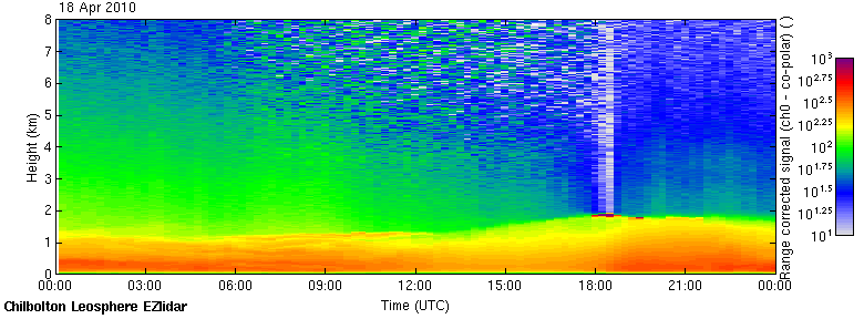
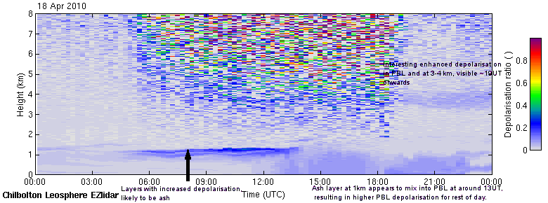
An ash layer can be seen immediately above the boundary layer, at a height of around 1 km, from 05UT until 13:30UT. It then becomes mixed into the boundary layer in a similar way to on 16th April and its presence can be detected there until the end of the day. Ash continued to be detected intermittently at the site until 20th April.